

In ZoneVu Frac, you can import Frac data to create a new Frac Plan or Job or append an existing Frac. This article will walk you through the process of importing a Frac and reviewing the import spreadsheet. You can download the most up-to-date version of the Frac Import Spreadsheet here: Frac Import Spreadsheet Download or here for the Frac Append Article: Appending New Data to an Existing Frac
Note: For the best importing results, do not delete any unused columns. ZoneVu Frac's importer can handle blank columns.
Importing Data into ZoneVu Frac:
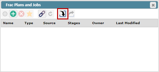
From the "Frac Plans and Jobs Menu," in the ZoneVu Frac module, click the "Import Frac from Excel File" button
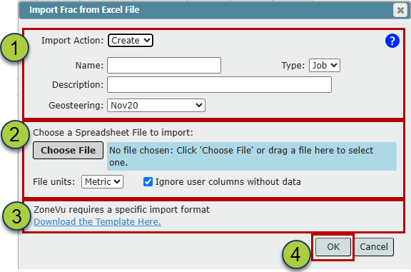
Fill out the Header Info
Name the Frac
Select the Frac Type: Plan or Job
Add a Description (Optional)
Select a Geosteering Interpretation to link
Drag & Drop or select the Frac file and indicate which unit type your imported data is in.
You can download the Import Spreadsheet using the "Download the Template Here" hyperlink
Click the "OK" button to import the Frac
Note that if you have the 'Ignore user columns without data' option checked on then named User Defined Columns in the import spreadsheet with no data in the columns will not be imported. If you unclick the option than any named column will be loaded with or without imported data present.
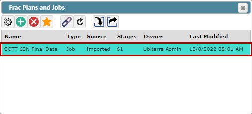
The imported Frac will now appear in the Frac List
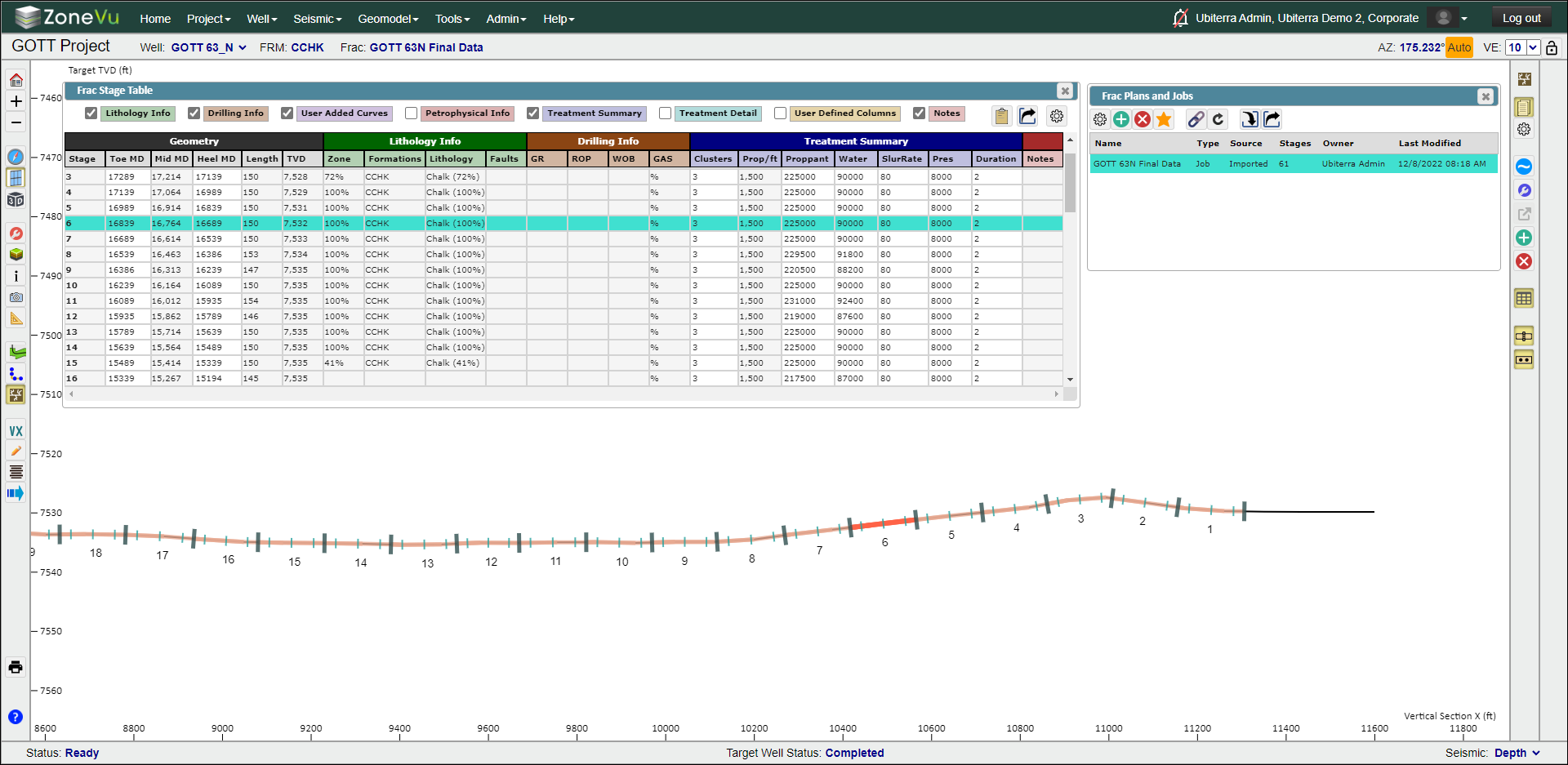
Once the import is completed, you will be able to see your Frac Stages, Plugs, and Perf Clusters along the lateral. If you open the spreadsheet button, you can also view the Frac Stage Table, which displays all of your imported frac information for that well.
Frac Import Spreadsheet: Frac Import Spreadsheet Download
Only the Stage Number, Toe md, and Heel md columns on the Stage tab are required for a frac import. All other data in the Spreadsheet is optional. If the Plugs tab is not filled in plugs will be auto calculated by ZoneVu to be located in the center between the end of one stage and the beginning of the next.
ZoneVu Frac uses the Column Headers and Tab Names to import the data; the Column order does not matter.
The column headers have been colored to help guide what data is Required (Red), Recommended (Orange), Suggested (yellow), and Ignored (Orange). Any columns that will be auto-calculated in ZoneVu Frac after import will be indicted by a (NOT imported) in read text. The 'Required' indicators on the Plugs and Clusters tabs should only be considered when importing plug and cluster data. If plug and cluster data are not being imported these indicators are not valid and the tabs may remain empty.

Note: For the best importing results do not delete any unused columns. ZoneVu Frac's importer can handle blank columns.
Note: Any frac import spreadsheet downloaded from ZoneVu will have sample data in each of the three tabs. These sample data will need to be removed before import.
Stages Tab:
The Toe and Hell MD columns define the Stage Length which is used to calculate the computed columns in the Stage Table. The Length of the Stage cannot exceed the distance of the bounding plugs. We recommend you use the Bounding plug depths for the Stage Heel & Toe MD depths unless you define the Stage Length using different parameters (i.e. - First to last cluster).
User-Defined Columns: User Defined Columns allows the user to import data that does not fit in the preset standardized columns of the ZoneVu Frac import spreadsheet. ZoneVu Frac will update the Column Names in the Stage Table with any text from the import spreadsheet added after the bar "|" in the header. For example, if a User Defined Column has a header of "User| 70/40 Mesh", after import, User Defined Column in the Frac Stage Table in ZoneVu will be renamed "70/40 Mesh". The User Defined Columns support floating point values (float).
Importing skipped stages: To import a skipped stage put "Skip" in the cell on the import spreadsheet for the stage geometry you would like skipped. Continue counting up from the last numbered stage after the skipped stage (s). If can un-skip a stage once you have imported the frac into ZoneVu. See Editing an Existing Frac in ZoneVu.
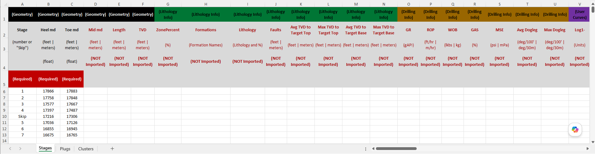
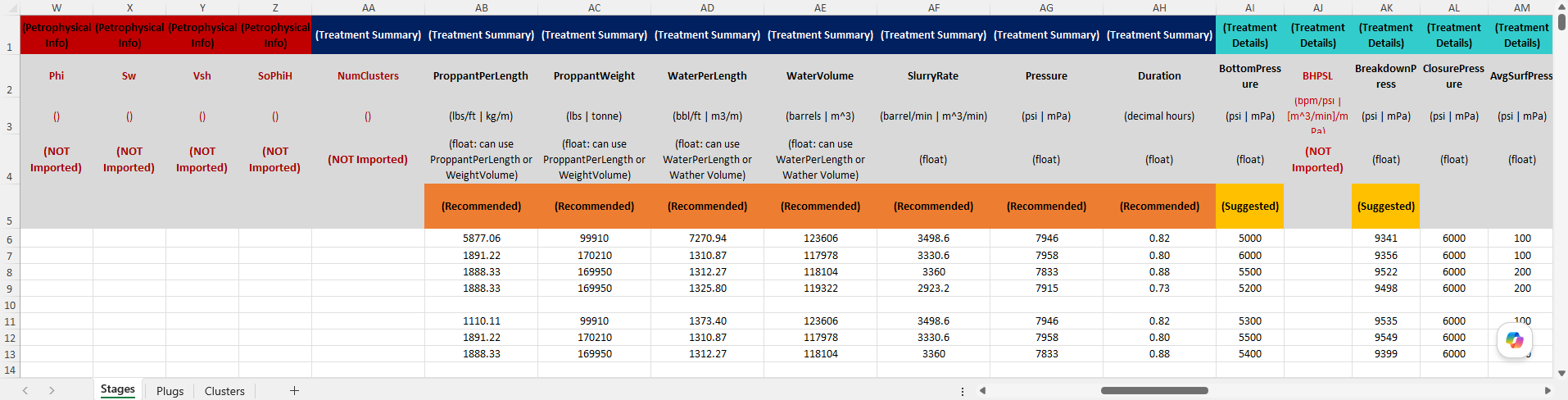
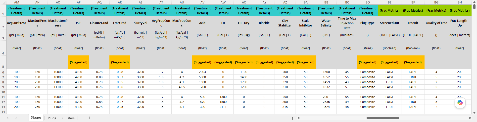
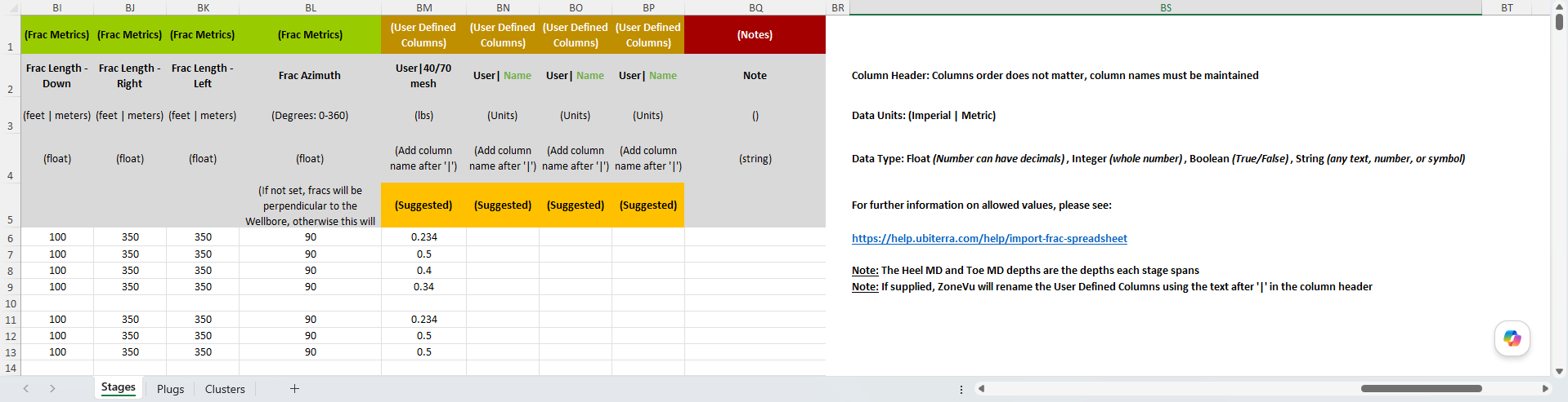
Stage: Stage Number
Toe md (ft): MD depth defining the Toeward most extent of the Stage: Usually the MD depth of the bounding Toe-Plug
Heel md (ft): MD depth defining the Heelward most extent of the Stage: Usually the MD depth of the bounding Heel-Plug
*Mid md (ft): Calculated mid-Stage MD depth
*Length (ft): Stage Length calculated from the Toe MD and Heel MD inputs
*TVD (ft): TVD Depth of the Wellbore at the mid-Stage MD depth
*ProppantPerFt (lbs/ft): Proppant-Per Foot calculated using the Stage Length and Total Proppant Weight
ProppantWeight (lbs): Total Proppant Weight for the Stage
WaterVolume (gallons): Total Water Volume for the Stage
SlurryRate (barrel/minute): Pumping rate for the Stage
Pressure (psi): Pumping Pressure for the Stage
Duration (decimal hours): Duration of the
ScreenedOut (TRUE | FALSE): Boolean values capturing if the Staged Screened out
FracHit (TRUE | FALSE): Boolean values capturing if the Stage caused a Frac Hit on a nearby Well
BottomPressure (psi): Bottomhole pressure for the Stage
*BHPSL (bpm/psi): Calculated - Slurry Rate / Bottom Hole Pressure
BreakdownPress (psi): Breakdown Pressure of the Stage
ClosurePressure (psi): Closure Pressure of the Stage
AvgSurfPress (psi): Average Surface Pressure of the Stage
MaxSurfPress (psi): Maximum Surface Pressure of the Stage
MaxBottomPress (psi): Maximum Bottom Hole Pressure of the Stage
ISIPPress (psi): ISIP Pressure of the Stage
ClosureGrad (psi/ft): Closure Gradient of the Stage
FracGrad (psi/ft): Frac Gradient of the Stage
SlurryVol (barrels): Total Slurry Volume for the Stage
AvgPropConc (lbs/gal): Average proppant concentration of the Slurry
MaxPropConc (lbs/gal): Maximum proppant concentration of the Slurry
User1| Name (integer): User Defined Column #1. All Text after the '|' will be used to update the Stage Table Column header
User2| Name (integer): User Defined Column #2. All Text after the '|' will be used to update the Stage Table Column header
User3| Name (integer): User Defined Column #3. All Text after the '|' will be used to update the Stage Table Column header
User4| Name (integer): User Defined Column #4. All Text after the '|' will be used to update the Stage Table Column header
User5| Name (integer): User Defined Column #5. All Text after the '|' will be used to update the Stage Table Column header
Note (text): Notes related to the Stage
*NumClusters: Number of clusters in the Stage
*ZonePercent (%): Calculated percent of the Stage that is in the Geologic Target, based on the associated Geosteering Interpretation
*Formations: List of all formations the Stage crosses, based on the associated Geosteering Interpretation
*Lithology (Text, %): List of all lithologies and the associated percentages the Stage encounters, based on the associated Geosteering Interpretation
*Faults (num, ft): Number of Faults and their throws that the stage crosses, based on the associated Geosteering Interpretation
*GR (API): Average Gamma-Ray Value across the Stage Length, based on the GR log used in the Geosteering Interpretation
*ROP (ft/hr): Average Rate-of-Penetration value across the Stage Length, based on the ROP log used in the Geosteering Interpretation
*WOB (klbs): Average Weight-on-Bit value across the Stage Length, based on the WOB log used in the Geosteering Interpretation
*GAS (%): Average Gas Value across the Stage Length, based on the Gas log used in the Geosteering Interpretation
*Phi (): Average Porosity value across the Stage Length, based on the Phi log or Type Well Top data used in the Geosteering Interpretation
*Sw (%): Average Water Saturation value across the Stage Length, based on the Sw log or Type Well Top data used in the Geosteering Interpretation
*Vsh (%): Average V-Shale value across the Stage Length, based on the Vsh log or Type Well Top data used in the Geosteering Interpretation
*SoPhiH (): Average SoPhiH value across the Stage Length, based on the SoPhiH log or Type Well Top data used in the Geosteering Interpretation
*Log1-: User Defined Log #1 - Average of the associated log across the Stage Length
*Log2-: User Defined Log #2 - Average of the associated log across the Stage Length
*Log3-: User Defined Log #3 - Average of the associated log across the Stage Length
*Log4-: User Defined Log #4 - Average of the associated log across the Stage Length
*Log5-: User Defined Log #5 - Average of the associated log across the Stage Length
*Log6-: User Defined Log #6 - Average of the associated log across the Stage Length
*Log7-: User Defined Log #7 - Average of the associated log across the Stage Length
*Log8-: User Defined Log #8 - Average of the associated log across the Stage Length
Note: any column marked with an '*' is a ZoneVu Frac calculated column and will not be imported
Plugs Tab:
The Plugs tab allows you to define the physical location of each plug in the Frac. In this spreadsheet, you will define the Toe plug for each stage and the plug location, including its thickness. In the example below the plugs for Stages #1-7 has been defined, with each plug having a width of 1'.
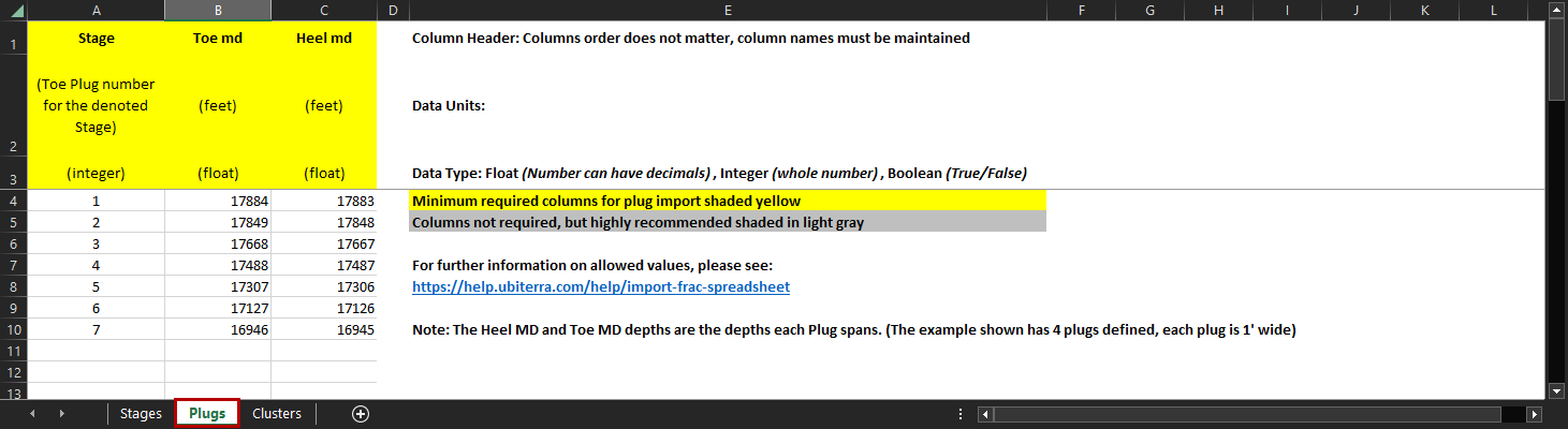
Stage: Stage Number associated with the Plug
Toe md (ft): MD depth defining the Toeward most extent of the Plug
Heel md (ft): MD depth defining the Heelward most extent of the Plug
Clusters Tab:
The Clusters tab allows you to define each Perf Cluster in the Frac, with each row representing a single Perf Cluster/Gun. The Toe & Heel MD columns define the physical location of each Perf Cluster, including the Perf Cluster thickness, and the Perf Clusters do not need to be evenly spaced or consistent between Stages. The remaining 4 columns are used to define the shot count, density, phasing, and orientation.
Note: if the Orientation column is blank or set to "0" the first shot will be oriented straight up. Positive values will rotate the first shot Clockwise, and negative values will rotate the first shot Counter-Clockwise
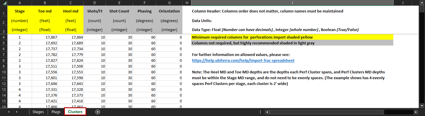
Stage: Stage Number associated with the Perf Cluster
Toe md (ft): MD depth defining the Toeward most extent of the Perf Cluster
Heel md (ft): MD depth defining the Heelward most extent of the Perf Cluster
Shots/Ft: Number of shot-per-foot
Shot Count: Total number of Shots in the Perf Cluster
Phasing (degrees): Shot spacing around the circumference of the Wellbore
Orientation (degrees): Number of degrees the first shot is rotated from vertical (Positive values = Clockwise Rotation)